
 |
| Oystercatcher, anchored in Lake Marion, South Carolina |
Every summer, and often every spring as well, a friend and I will take Oystercatcher on an extended journey somewhere in the Lowcountry of South Carolina. These journeys are normally coastal jaunts, northeastward or southwestward from Charleston to places like Cape Romain or the ACE Basin, but in the summer of 2020 we decided to do something a little different - sail Oystercatcher northward, up the Cooper River, through the Pineopolis Dam, and into Lakes Moultrie and Marion, together often called the Santee-Cooper Lakes, because of their connection to the Santee and Cooper Rivers.


Once you get past the North Charleston Port Terminal and the mooring field, the Cooper River becomes less industrial in appearance. The next landmark is the Goose Creek Naval Weapons Station, which I marked at the top of the above chart. The southern portion of this Naval Weapons Station sits on what used to be called "Snow Point," and some charts still label it that way. Yes, the U.S. Navy closed its base and shipyard in North Charleston in the 1990s but not this weapons station, which serves a variety of purposes today.
At the Goose Creek Naval Weapons Station, we encountered submarines of some sort for the nuclear submarine training school that exists here. The U.S. Navy takes security seriously in this area. A gun boat, which was patrolling the water near the floating fences in front of the submarines, noticed us and approached. The security personnel inside the glassed cabin of the boat didn't return our casual, "Hey-what's-up-man?" wave of the hand.


There was a dock for barges at Nucor Steel.


One thing that was discomforting to discover soon after we had entered the East Branch was that there were some uncharted power lines over the river. We judged them to be at a height of 50 feet, but we still held the starboard side of the boat as close as possible to the right bank, i.e., the southern bank, because the lines were higher along the shore. In the picture above you can see the power lines astern.

The Cooper River and its branches were once the heart of the plantation rice culture. The wooden "trunks," as they are called, were no longer present, but it was easy to imagine them being in place here along the river to control the flow of water in and out of the rice fields.

Why was it easy to imagine there being rice field trunks here? Because there are still many trunks here and there around the Lowcountry. The South Carolina Department of Natural Resources and other organizations use them to regulate old rice fields that now serve as preserves for ducks and other birds.

I had a copy of Claiborne Young's Cruising Guide to Coastal South Carolina and Georgia on board. Our goal was a certain landmark he discussed - Pompion Hill Chapel. The first red circle marks Middleburg Plantation, and the second one marks the chapel.

Not long before we came upon the chapel, we encountered an old chimney, and we could see a house and other buildings far beyond it.

Later, I would figure out that this was Middleburg Plantation, which dates to 1690, one of quite a few plantations that still exist along this river.

The old chimney and Pompion Hill Chapel were charted, as you can see.

On this map from 1842, you can see Pompion Hill Chapel with Middleburg just south of it.

Pompion Hill Chapel coming into view. The water was too deep to anchor near the chapel, so we went further upriver, where the depths were around nine feet, and dropped the hook.

We then took the dinghy to the shore. It was amazing to see this church from 1765 - when South Carolina was still a colony of England - in such good condition.

There were a few tombs, still intact, that were about the same age as the chapel.

This one dated to the 1780s.

It was right about this time that the cloudy skies gave way to the sunshine. The chapel did indeed sit on a small hill. You can see in the distance just how flat and marshy the land is on the other side of the river.

The chapel was locked, but we could get a good sense of the interior by looking through the windows.

Before we left, we paused to look upriver toward Oystercatcher.

I took this picture as we were leaving the chapel in our wake.


As we circled around Oystercatcher, so as to come alongside the starboard quarter, I took this picture with the chapel in the distance downriver.

Back on the boat, we ate some sandwiches for lunch and made plans for our next stage of the journey. We knew that after we returned to The Tee and started making our way up the West Branch of the Cooper, we would eventually encounter an obstacle - the Strawberry Chapel Trestle. This trestle did not have an active tender in place. The tender for the trestle spent his working hours farther upriver at the second trestle near the Pineopolis Lock and Dam. I had talked to him about a week before we had left Charleston to make sure the mechanisms on the trestles were in operation and that he would be available to open them. He said that they were and that he would be but that he had certain restrictions on the Strawberry Chapel Trestle. He would only open it during the working hours of the day, and he needed one hour advanced notice so that he would have time to drive down to this bridge. It had taken us 1 hour to reach Pompion Hill Chapel on a flood tide from The Tee. Based on this information, we estimated that it might take use 3 hours to reach the trestle. Therefore, after siesta time ended at 3PM, I called the tender and requested a 7PM opening, adding one hour to our estimate just to be safe.

The chart above, from south to north, indicates The Tee, Ruins, and the Strawberry Chapel Trestle.

Here's a close-up shot of the three landmarks.

From our anchorage upriver of Pompion Hill Chapel, we motored back through the many twists and turns of the East Branch of the Cooper to The Tee. We were running with the ebb tide, so it did not take us a full hour to return to The Tee. From The Tee, we began to head west and north up the West Branch of the Cooper, eventually reaching the charted ruins.

The ruins were of brick and seemed to be quite old. They were, perhaps, associated with the old Comingtee Plantation. That was my guess.

Eventually, the Strawberry Chapel Trestle/Bridge came into view. It was 5:30PM, an hour and a half before our scheduled bridge opening, so we dropped the hook in the sharp bend south of the bridge. Our estimated travel time between Pompion Hill Chapel and the Strawberry Chapel Trestle of 3 hours was fairly accurate given that we did not do any detailed calculations via the chart. It took us 2.5 hours instead of 3 hours. If the ebb on the West Branch had been stronger on this day, it easily could have taken us 3 to reach our destination.


We still had a long way to go to transit the area between Strawberry Trestle (pictured at the bottom of this chart) and Lake Moultrie. Our plan, for the time that remained on this day, was to get to Mepkin Abbey, or somewhere north of there.
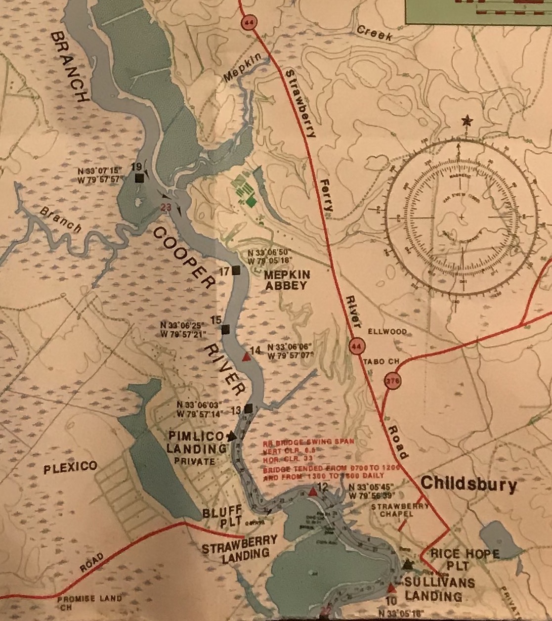

On the left bank of the river, i.e., the west bank, we started to see some of the houses of the Pimlico community not long after we passed through the raised trestle.

Some of them looked liked they'd been there for a while.

Most of them looked like they dated to the 1970s and later. The official, federal, aids-to-navigation, i.e., channel markers, continued to appear in this circuitous stretch of the river where these houses stood. Soon, however, they ended. We no longer saw them in the river or on the Garmin GPS aboard Oystercatcher. This transition occurred in the stretch of the river between these houses of the Pimlico community on the left bank and the grounds for Mepkin Abbey on the right bank.

Grounds of Mepkin Abbey above the West Branch of the Cooper River. Photo by Andy Hunter, Mount Pleasant Magazine. http://mountpleasantmagazine.com/2015/people/love-on-the-banks-of-the-cooper-river-henry-luce-and-clare-boothe-luce/ Many people in the Lowcountry are familiar with Mepkin Abbey. The monks used to sell fresh eggs, until regulators objected for some reason or another. Now they sell edible mushrooms. Mepkin Abbey stood on the grounds of what used to be Mepkin Plantation, as I would later learn in my research I would conduct on my smartphone in the evenings after we would anchor.

While I motored through this Pimplico and Mepkin Abbey area of the river, my buddy stood in the galley and cooked. We anchored upriver from Mepkin Abbey and enjoyed some good grub soon afterwards.

It made sense that the U.S. Coast Guard did not maintain aids-to-navigation north of Mepkin Abbey. Why? Because, as we discovered on this day and the day that followed, the West Branch of the Cooper River, from Mepkin Abbey north to the Pineopolis Lock and Dam, is well defined. Yes, there are some tidal plains here and there, but the main channel of the river is, for the most part, unmistakable. It's fairly narrow and lined with trees.

While we were at anchor, I took a few pictures of the boat, just to remember how we had stowed everything for this Santee-Cooper cruise. See the blue, 7 gallon, water jug? We learned from past experience to carry this whenever we went out for ten days on Oystercatcher. It was good insurance in the event that the internal water tank (and also the three, one-gallon jugs I carried in the
V-berth) ran dry.


This was a relatively peaceful, weekday evening at anchor. Still, though, we burned the spreader lights and the cockpit anchor light (in addition to the normal masthead anchor light) throughout the night, since there were various fishing boats and pleasure craft zooming up and down the river, even after dark. We figured these boaters weren't used to a sailboat being anchored in the middle of the river, so we decided to play it safe, even if it meant taking 10 amp hours off the battery bank because of the LED spreader lights.

The next morning, we spent an hour and a half charging the batteries while at anchor. We had some time to kill, because we had learned from the bridge tender the previous evening that the second railroad trestle, i.e., the one near the Pineopolis Lock and Dam, was under repair and would not be functional until later in the morning. While we sat there at anchor, we consulted the chart. We were somewhere between Mepkin Abbey and Lewisfield Plantation, probably closer to Mepkin that Lewisfield.


In the map above from 1842, you can see all the place-names I have mentioned in my description of our journey up the West Branch. There's Strawberry Chapel, Pimlico, Mepkin, Lewisfield, and Stoney Landing, and also the Santee Canal.

The Santee Canal used to join the Santee River to the West Branch of the Cooper River.

Note carefully that in 1842 both Wadboo and Biggin Church were upriver from Stoney Landing and the Santee Canal. It was in Wadboo, as I said, that the West Branch of the Cooper petered out.


It was Gilligan's, a local establishment that specialized in local seafood, with several locations, aside from this one, in the Lowcountry.


Knowing that the railroad trestle was not far away and that it was still not operational - because I had just phoned the bridge tender - we decided to kill some more time by exploring the Old Santee Canal.


The sign for the marina was so overgrown that we couldn't read it in full. It seemed to say, "Hunter's Club." If we were right, then that was its name at some point in the past, because, as we would soon discover, its present name was Hidden Cove.


We were surprised to find several large boats, including sailboats, in this marina. It was hard to imagine them transiting this remnant of the Old Santee Canal. Some of them obviously had people living aboard them, some not. Regardless, they all looked a little rough but proud, sort of like this area of the Lowcountry.


We thought there might be a marina store here, but we discovered that the building here at Hidden Cove in fact housed a bar and grill, one that appeared to cater to evening diners and also to late-night, hell-raising crowds. It wasn't open at this time of day. We met one of the liveaboards here. He was walking his dog named "Buckshot." As we were talking to this liveaboard, Buckshot ran and jumped into the water. The liveaboard then yelled out to his dog, "Buckshot, you better get your ass out of that water, 'fore one of them gators gets you." Buckshot listened, and an alligator went hungry this morning.


The chart had said nothing about these power lines between the trestle and the lock and dam. We could only assume that they were also at a height of 50 feet, and so beneath them we passed . . . without any
problems.


While the gates of the lock were still closed, we could monitor the level of the water inside of it, because jets of water shot forth from the joint between the two gates. When there were no more jets of water spewing forth, the gates opened, and several powerboats motored forth.


This is a view of the Tale Race Canal side of the lock. It had gates that were convex from our perspective. This made sense, because this made them stronger and better able to resist the force of the water in the lock, especially when full.

The Lake Moultrie side of the lock, on the other hand, had gates that were concave from our perspective. This made sense, because this made them stronger and better able to resist the force of Lake Moultrie pushing on them, especially when the lock was not full of water.


The winds tend to be quite strong and steady here (and along the coast) in the spring. I had, at various times, contemplated making this Santee-Cooper cruise during the spring, but I did have reservations about the winds, not so much about the winds themselves, but about the possibility of not being able to return to the Cooper River. The bridge tender had warned me that if the wind is out of the north and 20 miles per hour or higher, then the lock tender will not open the lock.


Here, we are transiting the area with the submerged rocks on either side of the channel.


After we passed under the bridge, we stopped at a place called Canal Lakes Fish Camp, a vacation spot with rough and ready cabins for rough and ready anglers eager to catch some of the famous catfish in this rustic, Santee Cooper paradise. Here, we took on fuel and water. We also enjoyed sitting in the rocking chairs on the porch of the store, drinking bottles of Gatorade and watching the boats go by. David Allan Coe's 1975 hit, "You Never Even Called Me by my Name," was playing in the background.


Lake Marion, named for Revolutionary War general, Francis Marion, the "Swamp Fox," is 110,000 acres in size. Interstate 95, which runs north to south along the East Coast of the United States, crosses Lake Marion on its western end. It is visible as a red vertical line on this chart. To the west of I-95 is Santee State Park, in orange.

The eastern end of Lake Marion is much wider and deeper, since it's on this end that the Santee Dam sits.


After we exited the Diversion Canal, it took a fair amount of motoring before we ever felt that we had truly entered Lake Marion.


The Santee Dam. A member of the Coast Guard Auxiliary, with whom I spoke before we ever left on this trip, told me that some people would cross the lake by motoring about one hundred feet off the dam, where the water was deep and there was less of a chance of encountering trees beneath the surface. You see, they flooded this land before they had ever finished clearing it of trees and stumps.


After we anchored, we took the dinghy to Sixteen Island so we could explore. In the distance is either Sandy Island or Church Island, or both. It was difficult to tell where one island began and another ended on this lake, but that's the way it is on other bodies of water in my experience.


Looking south toward Oystercatcher anchored in the distance.


Before we ever weighed anchor, we had sat around in the cockpit, looking at the chart, trying to make a plan for the day. We wanted to explore Church Island to the east, and we also wanted to explore Ferguson Island to the west. Church Island apparently contained the ruins of an old church and some old tombstones. Ferguson Island apparently contained the ruins of an old kiln.


I enjoyed looking at the arches of brick and imagining what it might have looked like when workers were stacking boards of cypress within.

I liked this view of the cypress trees, framed by the arch of the kiln. The cypress trees have persisted, while the Town of Ferguson, which once thrived on these trees, has not.


After he woke up, we spent some time looking at the chart, trying to decide what part of the lake we next wanted to explore. We considered motoring westward to the Interstate 95 bridge and Santee State Park (pictured in orange). We thought, though, that we might not have enough time to make it that far in the time that remained in this day.


We could now understand why it was labeled "Safe Channel." Why? Because on both sides of this channel we could see gnarled branches sticking up through the water and weathered trunks right around the surface. It was shame that this beautiful lake was so plagued with old trees. It would otherwise be an excellent place for full-blown power-boating or long, unimpeded tacks while sailing.


With my powerful, Waypoint, LED spotlight, we looked toward the shore, believing that we were closer to it than when we had anchored. Our biggest concern was not that we would be pushed onto this lee shore but that we would be pushed over some hidden tree or trunk that would hole the boat and cause us to sink. Fortunately, this did not happen, and eventually, after the wind and waves became somewhat more reasonable, we set up the generator. This was more challenging than usual on account of the waves.
When I climbed into the V-berth around 11:15PM there was still a lot of motion from the waves. With this, though, I was comfortable, and soon I was asleep. The next morning, we contemplated our next move. We thought about exploring some of the coves on this northern side of the lake, and we also contemplated going westward toward Interstate 95 and Santee State Park. Ultimately, we decided we wanted to return to the southern shore of the eastern end of the lake to explore Church island and some of the smaller islands around it.
 Yes, this was our plan, but it soon changed, about the time we tried to weigh anchor. We discovered that our 33 pound claw anchor, or perhaps our anchor rode, was thoroughly snagged on a stump or tree. The polyball trip-line was of no help to us, at least initially. In other words, we could not pull up the anchor with the trip-line.


As a last resort, I untied the end of the 200 foot nylon anchor line from its stainless steel eyelet in the chain locker, and buddy tied a polyball to the end of the nylon line and then threw all of it overboard, into the waters of Lake Marion. We then motored up to the polyball, grabbed the trip-line with the boat-hook, and freed the anchor from the snag. My buddy hauled up the anchor and the 50 foot chain and put all of this on deck. Then he started hauling on the 200 foot nylon anchor line. The polyball at the end of the line scooted across the top of the water in a way that suggested to us that the nylon line itself was snagged on a branch. Eventually it stopped scooting in this fashion, as if it had worked itself free of the snag.
This was it for anchoring in Lake Marion for us. We didn't want to press our luck any further. Mindful of the fact that we had brought gear for saltwater fishing and crabbing, and mindful that there were plenty of creeks in the Cooper River that we had not yet explored, we decided to leave these freshwater lakes behind us. Journeying back across Lake Marion, back toward the Santee Dam, back down the Diversion Canal, and back across Lake Moultrie, we eventually arrived at the Pinopolis Lock and Dam. A group of boats had entered the lock shortly before we arrived. Missing this opportunity to enter the lock, we had no choice but to motor in circles for almost an hour. By the time the gates of the lock finally opened, there were many other boaters - all powerboaters - eager to enter the lock. It was the weekend, and many people were letting loose, partying in the sun.
 We entered the lock before any other boats, but several powerboats zoomed around us and tied up to the floating dock forward of Oystercatcher before we could tie up to the dock.
 All these powerboaters seemed to know what to do when there was no more room available on the floating dock. They would throw lines to each other, enabling one row of boats and then another to raft-up against each other. No one attempted to raft-up against Oystercatcher. As you can see, she had the dinghy on her hip.
 The music was cranking and the liquor was flowing among these powerboaters as the waters of the lock churned beneath us all.
 After 25 minutes of idle time within the lock, some of these powerboaters made a hell-bent dash down the Diversion Canal toward the railroad trestle. We motored steadily past the crowd of powerboaters, who were waiting for the ride in the lock up to Lake Moultrie.

 At the point where the Diversion Canal turned into the West Branch of the Cooper River, we turned around and docked at Stoney Landing, where the Old Santee Canal Park now stood. The park itself was hard to detect from the water, because most of it sat on a tree-covered bluff.
 At the top of this bluff we discovered the Stoney Landing House, which dated to around 1843.
 Due to COVID restrictions, the house was closed. We were, however, able to walk around the grounds.


 Spanish moss in the drooping branches of a live oak tree - a common site around the Lowcountry.
 Nearby was a mock-up of the Santee Canal and it system of locks.
 This park was owned and operated by Santee Cooper, the power company that controlled much of the land around Lakes Marion and Moultrie.
 To return to Oystercatcher, we decided to hike a trail that would take us down to Biggin Swamp, which once formed the tail end of the Santee Canal.
 The bluffs in this area, as we learned, had apparently been built up from dead sea creatures long ago when the ocean covered this area.
 This is Biggin Swamp where the southern terminus of the Santee Canal once existed. Water from this swamp still entered the West Branch of the Cooper River, not far from where we had docked.
 It had been a long day, and my buddy and I decided that instead of cooking on this evening we would motor back up the Diversion Canal to Gilligan's Restaurant. It was only a short distance from Old Santee Canal Park, but it took us quite a while to get there due to the strong current in the Diversion Canal at this time.
 In the restaurant, my buddy dined on crab legs, and I enjoyed a crab burger, i.e., a hamburger with a crab cake on top of it. Good eatin'. Afterwards, we looked at the catfish they had in an aquarium and the "world's record" catfish they had as a trophy on the wall.
 As we neared Mepkin Abbey and the area around the Pimlico Community, I almost ran aground at the point where the Molly Branch flows into the river. There is a charted marker 19, but it was not present. From my vantage point upriver, it appeared the river turned westward at this point, when in fact it flowed southward. If I had not glanced down at the GPS and noticed the breadcrumbs from our trip upriver, I would have entered the tidal flats around Molly Branch.
 We motored past Mepkin Abbey and tried to anchor in the area around Pimlico Landing. Here, the water is wide on both sides of the river. We figured that we could find some moderately deep water in this area outside of the marked channel of the river. We found only shallow water, i.e., water 2-3 feet deep, so we turned around and motored back up to a spot just north of Mepkin Abbey, a spot where we could see the grass of the abbey, grass which led down to the water. We did not find success in our first attempt at anchoring in 15 feet of water with 175 feet of rode. We did though find it when we tried again.

 I took this picture as we made our way through the Pimlico area. You can see some of the tidal flats to the left.
 This gives you more of a feel for just how wide the West Branch of the Cooper is in this Pimlico area. The water is deep in the marked channel, but dangerously skinny outside of it. Without a GPS with breadcrumbs or without local knowledge, you could easily run aground if the charted aids-to-navigation were not present here.
 Our timing was nearly perfect. We arrived at this area north of the Strawberry Chapel Trestle at 0858, two minutes before our scheduled bridge opening. The bridge tender appeared to have seen us approaching, because he started to open the bridge without us having to hail him (on the cell phone).
 Just after we passed under the trestle, my buddy took the helm, and I went below to use the head. Shortly afterward, while in the head, I suddenly heard vegetation rubbing along the hull of the boat. Then I heard my buddy throwing the motor into reverse and trying to go full astern. We had run aground earlier in the trip when trying to enter a remnant of the old Santee Canal, but we had been able to back off that sandbar. That was probably because there was no tidal influence upriver near the Highway 52 bridge. Here, though, there was a tidal influence, and the tide was on the ebb. Despite our best efforts, Oystercatcher would not budge.
 Just south of Rice Hope Plantation and the charted Sullivan's Landing, there was a large tidal flat. When my buddy had taken the helm in that large bend, it seemed the course of the river went into that area of the tidal flats when in fact it did not. We had brief tiff over why this had happened, but it didn't matter, because we had both run aground before. Soon, I was untying the anchor line from the chain locker inside of the V-berth, and he was removing the anchor, the chain, and the line and placing it in the dinghy as he stood there in the dinghy at the bow. He then rowed the dinghy out to the deeper water near the river proper and dropped the anchor so we could try to kedge off of these tidal flats.
 A man who lived in one of several houses along the water in this Rice Hope area, saw what we were doing and came over to Oystercatcher to speak with us. He had grown up in this area and had spent his career in the fishing industry of the Lowcountry, and it turned out that he knew different members of my buddy's family. His boat was thoroughly bad ass - one of those types of boats we had seen screaming up and down this river. It was an aluminum skiff with an outboard, whose prop was protected by cage. He only needed about a foot of water to get where he wanted to go, and he had no problems this morning, circling around us in the shallow water.
 It was about 0930 in the morning, and the man estimated that it would be around 1500 before the boat would float again. He said we were welcome to come over to his place, if we needed anything, and then he left. As the the minutes slipped away Oystercatcher began to list, not terribly so, however, because the bottom was flat and muddy. We were dripping wet from our exertion in the hot, Lowcountry sun, and so after we changed shirts, we sat down below with the fans in the main salon pointed at us, drinking water and trying to cool down.
 To pass the time, we looked at the chart and thought about the nature of the river. We thought about the tidal plains that we were in, and we thought about the tidal plains around Molly Branch, where I had almost run aground the previous evening. We surmised that it was around this Rice Hope-Molly Branch area of the river that the tidal influence started and ended and that the point where the river overpowered the tidal influence varied depending upon the amount of water coming downriver out of the Lock and Dam and upriver from the Atlantic Ocean.
 We ate an early lunch, and afterwards my buddy took his regular siesta, and I spent time updating my Ship's Log Journal. Around 1300 my buddy woke up, and we began to strategize about how we might be able to free ourselves from this tidal flat earlier than 1500. My buddy thought that we should take the spare anchor and set it as a second kedge anchor. About the time that we were starting to think seriously about this, it seemed that Oystercatcher was starting to right herself from her list. We looked outside, and it was clear that the tide was coming in. Shortly afterward, I fired up the motor and put it in reverse, and slowly but surely Oystercatcher began moving astern. It was 1330, and soon we were retrieving our kedge anchor and making our way southward down the West Branch of the Cooper.
 From the Tee, we made our way southward, down the upper reaches of the Cooper River proper.
 The first major landmark was the Williams Power Station, the coal fired plant I discussed on our trip upriver. In the same bend of the river was W International, a high-tech, metal-working shop that does contract work for the U.S. Navy.

 Between W International and the Williams Power Station was a small branch of Detyens Shipyard. This small yard, as you can tell, specializes in shrimp boats, barges, and other such boats of this size, unlike Detyens proper, farther downriver, which specializes in large ships.
 In this detail from the previous photo, you can see a shrimp boat being hauled out by a travel-lift.
 Here's a close-up view of this area.
 We motored a little bit further south down the Cooper River and then turned eastward into Grove Creek to anchor for the night. We anchored at the 9 foot mark on the chart in 11 feet of water with 50 feet of all chain rode between two well-spaced crab pots. In the distance, south of Back River, or Bushy Park Reservoir (bottom left), we could see the northernmost end of the Naval Weapons Station, and we would hear the bugle call for the the flag-lowering ceremony near sundown.
 I wrote in my Ship's Log Journal that it was nice and breezy here with winds from the southwest and few bugs. I also wrote that there was no spartina grass here, as in the marshes closer to Charleston. There was, instead, a different kind of grass and also plants with dark-green leaves.
 On this evening, I pulled galley duty, cooking brats and canned potatoes (from a Mason jar) with onions in butter. Meanwhile, my buddy baited up the fishing rods with shrimp to try his luck in this creek. Soon he had a bent rod.
 Up into the cockpit he pulled this ray.
 No luck on this evening other than this scavenger, which my buddy threw back in the water.
 Later in the evening, we read online on about the nearby Bushy Park Reservoir. We learned that back in the 1950s they had damned up what used to be Back River - a tidal, saltwater river - to create this freshwater reservoir. They dug the Durham Canal from the West Branch of the Cooper River south of Strawberry Chapel trestle to feed freshwater into this reservoir, which was and is the primary source of water for the Charleston area.
 The next morning, as we were drinking our coffee, we watched a crabber checking his pots. In the distance, you can see him making his way up Grove Creek. Soon after 9AM we were in the dinghy, heading in the same direction. At this time it was 1.5 hours before the low tide, and our goal was to do some cast-netting so as to catch some bait.
 Here, you can see our anchorage (red circle, 9 feet). The Grove, which gives Grove Creek its name is the site of the former plantation of the same name. Today, there's a pavilion and fire pit here, a place out in the middle of nowhere where people hold events such as oyster roasts and barbecues. I had been to several events here in the past. We took the dinghy past the dock for this event space, and we continued until we reached a fork, at which point we took the right fork.
 Here and there along the way, we motored up into some shallows so my buddy could throw the cast-net. We didn't have luck catching any bait in these areas. We surmised that the water was too fresh. I should notes that it was on this cast, or one of the others, that my buddy ended up with a pocket knife in the side of his foot. Keep reading for details.
 We continued to the area of the large red circle on the chart. Here, we investigated the clay on the banks of the creek. We had read that The Grove was a plantation, like several other Lowcountry plantations, known for its brick.
 We eventually reached a point where we could go no further because of a tree that had fallen and blocked the creek. At this point, we turned around and began to make our way back toward Oystercatcher.
 Back in the main part of Grove Creek, we stopped again to investigate the clay. Along this bank, the clay was orange, unlike the clay on the bank farther upstream, which had been grayish white.
 When we were almost back to the boat, we passed by a dock for the BP plant. We had passed this dock on our way up the creek. It appeared that this dock was for barges, and it appeared that the BP company had excavated and dredged this site when they had constructed this dock. As is the case with Nucor Steel, the BP plant is not really visible from the Cooper River or side creeks such as these. The river and marshlands, for the most part, appear quite wild.
 You can see this excavated docking area on the chart. It's to the left of my "Grove Creek" label.
 At last Oystercatcher was back in sight. This had been a long dinghy ride.
 Back in the boat, my buddy demonstrated how he had managed to stab himself in the foot when he was throwing the cast-net. The open knife sat on the bench-seat where he stood. When he threw the net, his foot slid up against it. This wasn't just a superficial wound. The knife was sticking out the side of his foot. Fortunately, there was no serious damage.
 After lunch and siesta time/ship's log journal time, my buddy spent some time mending the cast-net. Note the sun shade that I had installed. I had sewn this shade out of Sunbrella canvas several years before this time. It's really helpful for blocking sunlight when the cockpit is unavoidably exposed to it on account of the set of the tide.
 Around 4PM we weighed anchor and made our way southward, down the Cooper River to Flagg Creek. This is the large creek opposite the submarine facility at the Naval Weapons Station. My label on the bottom left of the chart, which says, "Goose Creek Naval Weapons Station," is a bit misleading. The Naval Weapons Station actually extends upward toward the Bushy Park Reservoir. This southern part of it across from Flagg Creek just happens to be the most visible part of it from the water.
 The security boat with the 50 caliber machine gun escorted us through the submarine area and watched us as we entered Flagg Creek. We favored the southern entrance of the creek to avoid the shoals on the northern side and center. We motored to a point just beyond the security zone demarcation line and anchored with 50 feet of chain in 15 feet of water at, or around, high tide. It was here, in Flagg Creek, that we began to notice spartina marsh grass again. This made sense, because the official, South Carolina Department of Natural Resources (SCDNR) demarcation line for saltwater and freshwater fishing is at the mouth of Back River, or what everyone now calls Bushy Park Reservoir.
 After we anchored, my buddy baited up the fishing rods and then got to work baiting up one of the crab nets.
 We had used metal crab pots on other Lowcountry journeys, but on this one we tried our luck with nets.
 While he was working on the nets, I was in the galley, cooking up some mahi mahi, cheese grits, and field peas. The mahi had been abundant this summer. My neighbor had caught a bunch of them offshore and given me some right before this trip. These, though, if I remember correctly, my buddy had gotten from one of his neighbors.
 Not long after I had finished cleaning up the galley, the sky darkened to the northwest, and soon the cool wind began to blow from that direction.
 The weather report indicated that this storm had hail and gusts up to 45 miles per hour.
 Fortunately, it passed by us without hitting us.
 It made for a beautiful sunset, and all seemed well at this point, but soon another storm appeared to the northwest over Lake Moultrie, as indicated by the radar. This one looked like it was going to go right over us, so we made preparations and went down below. There, my buddy worked on some new knots he had been reading about in The Marlinspike Sailor, and I worked on the Ship's Log Journal.
 The next morning, after our coffee, we set out from our anchorage in the dinghy. We had anchored, as I said, along the edge of the security zone, marked with the dotted red line on this chart. About a hundred yards up the creek, we dropped the first crab net. Its floatation device immediately disappeared beneath the water. There was no way for us to see it. This crab net was a loss. We reasoned that the depth of the water must have been much deeper than the charted depth.
  We then motored to the area of the second red circle on the chart and dropped the next crab net there. Then we motored to the creek over which the BP train trestle stretched. This was a low-lying trestle. It was about 1.5 hours before low tide, and it was clear from the water marks on the trestle that at high tide it would be difficult or impossible to pass underneath the trestle. We returned to Flagg Creek proper and motored to the area of the fourth circle on this chart. Here, there were pine trees along the bank, and there was no spartina grass. Instead, there were water plants like those we had seen one day earlier in Grove Creek to the north. We decided that this was not a good area for using the cast-net, since it appeared that this was a freshwater ecosystem. We were also worried about running out of gas, because we had traveled a long distance to get here, so we turned around at this point.
 Back in the area of Flagg Creek where the spartina grass was abundant, we found a small feeder creek and motored up into it. There, in about 2 feet of water, we found success with the cast-net.

 Then we started checking the crab nets.
 A keeper.
 After we got back to Oystercatcher, we ate lunch and then had siesta time/Ship's Log Journal time.
 Afterwards, we weighed anchor and motored down the Cooper River to the next set of creeks -- Yellowhouse Creek and Clouter Creek. We considered anchoring in Yellowhouse, but ended up opting for Clouter.
 The light green circle marks our anchorage on Clouter Creek. The large red circle marks the North Charleston Port Terminal, the small red circle marks the paper mill, and the large red line marks the approximate location of present-day Interstate 526. Despite the fact that we were close to these different structures, this anchorage was still fairly secluded. It was impossible to see the port terminal and mill, because the marshy area between Clouter Creek and the Cooper River was covered with dredge spoil and trees that had grown up around this hilly, dredge spoil area.
 After we got situated, we cut some bait for the crab nets and then set the nets with the dinghy.
 The sting rays were biting on this evening.


 Later on, my buddy cooked some steak in the cast iron skillet and then fried up some shrimp in bacon grease that we had saved in a Mason jar from the bacon I had fried up on Lake Marion several nights earlier. We had brought this shrimp with us and kept it in the Engel fridge the whole time. It had come off Captain Wayne Magwood's boat, The Winds of Fortune, his last haul before selling this boat and retiring from a life of shrimping. Good stuff.
 Later that evening, just before dark, we checked the crab nets and found these two crabs.
 Afterwards, we sat around in the cockpit as usual. As soon as it became dark, we started noticing that mosquitoes were biting us. We applied some No Natz and some Skin So Soft, which normally would keep the bugs away. On this night, however, this stuff didn't work. Soon, we realized that we were being swarmed, and we could only guess that the swarm was coming from the nearby dredge spoil impoundment, which was probably full of fresh water. We had experienced something similar on account of an old rice impoundment near Cape Romain in the past.
 Knowing from past experience that a fight of this sort was futile, we quickly set up the generator, shut ourselves inside the boat, and started the air conditioner. When we turned on the lights inside the boat, we discovered what seemed to be thousands of mosquitoes within. Over the next thirty minutes, in three different bloody killing sessions, we eliminated all the mosquitoes and were finally able to sit and enjoy the cool air.
 The next morning, we checked the crab nets and then steamed the crab in a small steamer pot that my buddy had brought along with us.
 These crab made for a great breakfast on Clouter Creek and a good finale for this trip up and down the Cooper River.
 After we weighed anchor, we motored down Clouter Creek along the edge of Thomas Island, which everyone now simply calls Daniel Island. Soon, we were back in the Cooper River, and soon were were back down in Charleston, where we had begun. We spent much of the afternoon hauling stuff back home and cleaning that stuff up. Later that evening we returned to clean up the boat.
 This trip was much different than I had expected it to be. I had learned a lot about the Cooper River - its past and its present - and I had enjoyed experiencing the transitions from saltwater to brackish to fresh and back again as Oystercatcher made her way up to Lakes Marion and Moultrie and then back to Charleston. It was a good mixture of experiences - from fishing and crabbing to exploring - and it was a good time. I would do it again and hope that one day I will.


The current in the Diversion Canal was considerably stronger than it had been when we had motored up it, several days earlier. At 9.2 knots, this was the fastest that Oystercatcher had ever traveled, at least in my time aboard her. Notice the breadcrumbs on the plain yellow background. Recall that ever since we had motored through the Pimlico area farther downriver (on our journey up to the lakes), we had not seen anything on this GPS chart except our own breadcrumbs.


We enjoyed observing the craftsmanship that's all but disappeared from present-day construction.


This was what we saw through the front porch window. It looked like the floors were of heart pine, i.e., old growth, longleaf pine, a common flooring material in old houses in the Lowcountry, especially in downtown Charleston, where many of old houses still exist.


Our journey down the West Branch of the Cooper on this evening from Gilligan's Restaurant (near the Highway 52 bridge marked in red), was swift, but not as swift as it had been initially before we had entered the restaurant. I noted in my Ship's Log Journal that it appeared the Lock and Dam had adjusted the flow of the water while we dined.


The next morning we arose around 0600, which was the norm for us. We had a little time to kill while waiting for the bridge opening we had scheduled for 0900, so we spend about 1.5 hours putting a charge on the battery banks with the Honda generator. At the start of this trip, I had noticed that my Victron battery monitor was not working, so there was no way to get an accurate sense of the state of charge of the house bank. We just had to feel it, i.e., use our intuition about when it needed a charge.

At 0830 we weighed anchor and began to motor southward toward the Strawberry Chapel Trestle.


I threw him one of my spare anchor lines, and he tied this to his stern. I wrapped the anchor line from the kedge anchor around one of the cockpit winches and put a lot of tension in it with the winch handle. Around the other cockpit winch I had wrapped the tow line. At our agreed upon signal, the man went full throttle on his boat, and I started cranking on the kedge line. All of our efforts came to naught.


With several casts, my buddy hauled in plenty of finger mullet as bait for fishing and crabbing purposes. Included in the haul was one bull mullet, i.e., an adult mullet, and a small pin fish.


I ran across your blog while looking for a photograph. I took the photo of LEADBELLY, my Ericson 25, from eons ago. I took it for Ericson Yachts and it appeared on the inside back cover of Yachting Magazine.
ReplyDeleteLEADBELLY was my first " big boat" after years of racing one-designs. Although marketed as as a small first cruiser, it happened to qualify in the a quarter-ton category of rhwInternational Offshore class (IOR). So we raced her in a very competitive fleet out of Chicago. We won first overall in her first season, beating many racing designs. Her biggest victory was fist overall in a flee of about 75 boats in the annual Great Lakes Cutlass Race where we beat all boats over the line in a 40 mile race under spinnakerin heavy air. With the board up, she flew!
I loved that little boat and my wife and I also cruised extensively around Lake Michigan. I am glad to see you are keeping thwclass alive. It is a great boat.
Do you have any larger images you could send me? I have lost track of my negative.
Bill, you have some great stories! I've uploaded some high-def images of the advertisement and the boat itself to the same Leadbelly page that you discovered. Love the name of your boat! So fitting. What year were these races?
ReplyDelete